Char Dham Yatra Route Map: In Hindu mythology, the Char Dham yatra experience means divinity. The Chardham yatra route boasts four sacred pilgrimage sites in Hinduism, each having its importance. Yamunotri is the sacred place dedicated to Goddess Yamuna, and it is located at a very high altitude, which is typical of the Rawai Valley, with its incredible natural beauty.
Gangotri symbolizes the Goddess Ganga. Kedarnath, a part of Panch Kedar, represents the temple of Lord Shiva there. Badrinath stands on the banks of the river Alaknanda and is dedicated to Lord Vishnu.
Char Dham Yatra Route Map
Let us take you through the best route to Chardham Yatra along with sight shinings in the vicinity as well as the most comprehensive suite of accommodations with online booking and lastly a budget-friendly Chardham package which is perfect for your next family trip or group and will be Chardham.
The Char Dham Yatra is a religious tour path in India that covers four holy sites: Yamunotri, Gangotri, Kedarnath, and Badrinath. This is the best route for the Char Dham Yatra. Moreover, be sure to verify the Chardham Yatra opening and closing dates to plan your Chardham trip.
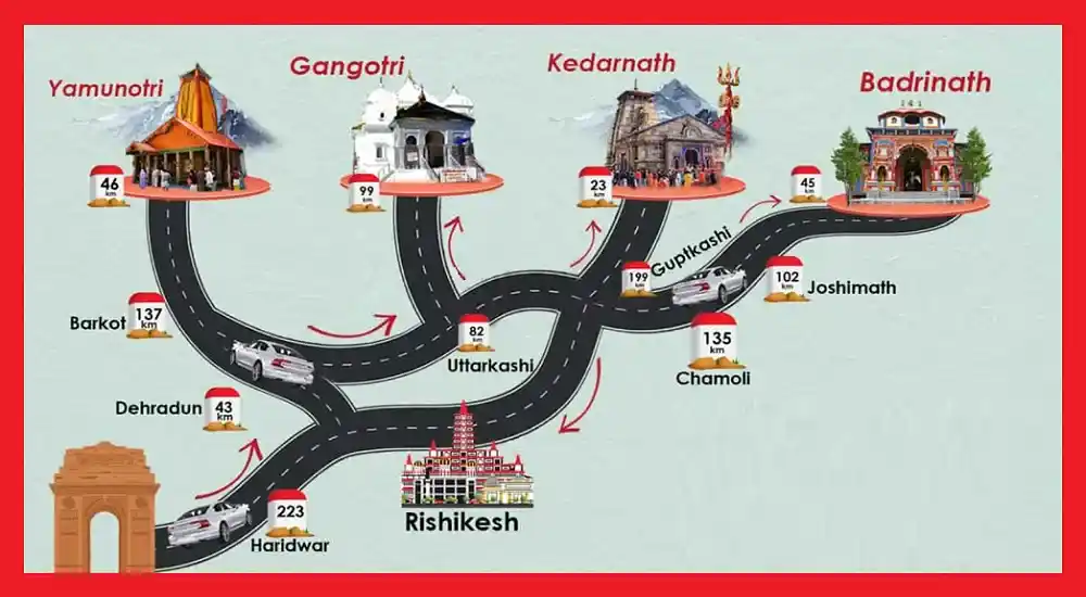
Chardham Yatra Road Route Map with Distance
Uttarakhand is called the Land of Gods “DevBhumi” and is a Home of Gods, with the towering peaks of the Himalayas. Among the pious mountains, lurk the famous Temples of Char Dham in the Garhwal Himalayas. The Char Dham Yatra is an expedition to the four major holy places of the Hindus namely Badrinath, Kedarnath, Gangotri & Yamunotri.
All four of the holy Dham belong to the different Goddesses, while the Badrinath Temple is meant for Lord Vishnu and so is the Kedarnath Temple for Lord Shiva, while the Gangotri & Yamunotri Temple are for the Goddess Ganga & Yamuna rivers. The Char Dham Yatra is essentially the most devout yet such a spiritual tour of Uttarakhand.
Chardham Route Map (Google Map)
The Char Dham places are situated in the lap of natural grandeur, which portrays the beauties of the whole Uttarakhand region in thousands of ways. There, the Char Dham sites are seen from many angles, making the green land look more beautiful, and a tourist feels like he/she falls in love with the nature that surrounds them.
This season, when pilgrims start their holy journeys, the first stop is going to be Yamunotri, then Gangotri, Dias Kedarnath, and finally Badrinath to wind up the trip. The Char Dham yatra is very easy and uncomplicated. All the roads are connected very well.
| Yamunotri | The first site on the Char Dham Yatra is Hanuman Chatti. Besides Haridwar and Rishikesh, you may also visit Hanuman Chatti by road. From Hanuman Chatti, on the other hand, you can either walk or go on a pony ride to reach Yamunotri. |
| Gangotri | After visiting the first pilgrim stop up, Yamunotri, you’ll be heading off to Gangotri. You go back to Haridwar or Rishikesh and then you continue proceeding along Gangotri accessible by road. |
| Kedarnath | After visiting the first pilgrim stop-up, Yamunotri, you’ll be heading off to Gangotri. You go back to Haridwar or Rishikesh and then you continue proceeding along Gangotri accessible by road. |
| Badrinath | After Kedarnath, you cannot miss to visit Badrinath. Kindly note that you shall be returning to Haridwar or Rishikesh from the temple of Kedarnath. Road takes you to Badrinath the next destination of your trip, that’s the way you can reach it. |
Yamunotri Dham Route Map
Starting the yatra by the Chardham yatra with Yamunotri the place that is master of Goddess Yamuna. The following are the directions on how to reach Yamunotri. It is the initial point where the char dham yatra starts. It can be got to Hemkunt saheb through Hanuman Chatti by road from Haridwar or Rishikesh.
Haridwar to Yamunotri Route Distance (Via Dehradun)
Haridwar – Dehradun – Barkot – Jankichatti – Yamunotri (224 km Approx)
| From | To | Distance(Approx) |
|---|---|---|
| Haridwar | Dehradun | 53 km |
| Dehradun | Barkot | 140 km |
| Barkot | Janki Chatti | 45 km (by road) |
| Janki Chatti | Yamunotri | 6 km (Trek) |
Haridwar to Yamunotri Route Distance (Via Rishikesh, Chamba)
Haridwar – Rishikesh – Narendranagar – Chamba – Dharasu – Barkot – Jankichatti – Yamunotri (270 km Approx)
| From | To | Distance(Approx) |
|---|---|---|
| Haridwar | Rishikesh | 20 km |
| Rishikesh | Narendranagar | 20 km |
| Narendranagar | Chamba | 45 km |
| Chamba | Dharasu | 78 km |
| Dharasu | Barkot | 61 km |
| Barkot | Jankichatti | 45 km |
| Jankichatti | Yamunotri | 6 km (Trek) |
Important Place to Visit in Yamunotri
Yamunotri, which is situated in the Garhwal Himalayas of Uttarakhand, is commonly referred to as the source of the River Yamuna and has been of great religious importance to Hindus. Here are some places to visit in and around Yamunotri
| Place | Description |
|---|---|
| Yamunotri Temple | Hot water springs for cooking offerings. |
| Surya Kund | The starting point for the Yamunotri trek is known for its thermal springs. |
| Divya Shila | Holy rock pillar for prayers. |
| Janki Chatti | Scenic village with ancient temples, accessible by a short trek. |
| Kharsali | It is a scenic village with ancient temples, accessible by a short trek. |
| Hanuman Chatti | Small town for resting during the journey. |
| Barkot | A town with views of the Himalayas, a popular stopover. |
| Syana Chatti | A town with views of the Himalayas, a popular stopover. |
Gangotri Dham Route Map
After Yamunotri, Gangotri is the next place to go. You will come back to either Haridwar or Rishikesh first and then you proceed to Gangotri. Gangotri, which is located at the intersection of roads, is the first place after returning from Yamunotri on your Char Dham Yatra journey. Ganga the river that flows from Gaumukh to Bhagirathi, one of the four spiritual centers of Hindu mythology lives in this holy place.
Yamunotri to Gangotri Route Distance
Yamunotri – Jankichatti – Barkot – Uttarkashi – Harsil – Gangotri (225 km Approx)
| From | To | Distance(Approx) |
|---|---|---|
| Yamunotri | Jankichatti | 6 km (Trek) |
| Jankichatti | Barkot | 45 km (by road) |
| Barkot | Uttarkashi | 80 km |
| Uttarkashi | Harsil | 78 km |
| Harsil | Gangotri | 25 km |
Important Place to Visit in Gangotri
Gangotri-based tourist attractions are plenty long before the sightseers arrive, so pilgrims have to see most of them on their tour of the place. In this regard, some popular destination names are to be given in your itinerary to make your trip memorable.
| Place | Description |
|---|---|
| Gangotri Temple | Sacred rock is linked to King Bhagirath’s legend. |
| Bhagirathi Shila | Caves were believed to be used by the Pandavas during exile. |
| Pandava Gufa | Glacial Lake known for trekking and beauty. |
| Gaumukh Glacier | A source of the Ganga river is accessible by trek. |
| Submerged Shivling | Natural rock formation near the temple. |
| Tapovan | Scenic meadow with views of Himalayan peaks. |
| Kedar Tal | Glacial Lake is known for trekking and beauty. |
| Harsil | Glacial Lake is known for trekking and beauty. |
Kedarnath Dham Route Map
The temple is located on the Mandakini River on the highest hill (3584 m above sea level) in Kedarnath. Kedarnath is one Jyotirlinga out of 12 ones. Kedarnath is easily accessible since the road to it is well-maintained. The Famous Kedarnath Jyotirling of Lord Shiva holds a divine place where Lord Shiva is said to appear as a fiery column of light.
Gangotri to Kedarnath Route Distance (Via Ghansali)
Gangotri – Harsil – Uttarkashi – Ghansali – Tilwara – Agastyamuni – Guptkashi – Gaurikund (by road) – Kedarnath (by trek) (337 km Approx)
| From | To | Distance(Approx) |
|---|---|---|
| Gangotri | Harsil | 25 km |
| Harsil | Uttarkashi | 70 km |
| Uttarkashi | Ghansali | 60 km |
| Ghansali | Tilwara | 98 km |
| Tilwara | Agastyamuni | 10 km |
| Agastyamuni | Guptkashi | 28 km |
| Guptkashi | Gaurikund | 30 km |
| Gaurikund | Kedarnath | Approx 16 km (Trek) |
Gangotri to Kedarnath Chardham Route Distance (Via Srinagar, Rudraprayag)
Gangotri – Harsil – Uttarkashi – Tehri – Srinagar – Rudraprayag – Augustmuni – Guptkashi – Gaurikund – Kedarnath (by trek) (375 km Approx)
| From | To | Distance(Approx) |
|---|---|---|
| Gangotri | Harsil | 25 km |
| Harsil | Uttarkashi | 70 km |
| Uttarkashi | Tehri | 60 km |
| Tehri | Srinagar | 80 km |
| Srinagar | Rudraprayag | 34 km |
| Rudraprayag | Augustmuni | 32 km |
| Augustmuni | Guptkashi | 28 km |
| Guptkashi | Gaurikund | 30 km |
| Gaurikund | Kedarnath | Approx 16 km (Trek) |
Important Place to Visit in Gangotri
Located in the Himalayan state of Uttarakhand, Kedarnath is an area of major spiritual significance and floral and faunal beauty. Below are some places you might like to visit while in Kedarnath.
| Place | Description |
|---|---|
| Kedarnath Temple | Ancient temple dedicated to Lord Shiva |
| Chorabari Tal | Glacial lake with stunning views |
| Vasuki Tal | High-altitude lake amidst Himalayan ranges |
| Shankaracharya Samadhi | The meditation spot is believed to be where Lord Shiva meditated |
| Bhairavnath Temple | Temple dedicated to Bhairav, near Kedarnath |
| Triyuginarayan Temple | Believed to be Lord Shiva’s wedding site |
| Gaurikund | Starting point of Kedarnath trek, religious significance |
| Sonprayag | Scenic spot at Mandakini and Basuki rivers’ confluence |
| Rudra Cave | Meditation spot is believed to be where Lord Shiva meditated |
Badrinath Dham Route Map
Situated at 3133 meters above sea level, on the left of the Alaknanda River, this hallowed place is a shrine to Lord Vishnu. The story goes that Lord Vishnu performed penance here. The Badrinath temple is Located in the Garhwal Himalayas, on the banks of the River Alaknanda, and the sacred town lies between the Nar and Narayana mountain ranges.
Kedarnath to Badrinath Route Distance
Kedarnath – Gaurikund – Guptkashi – Augustmuni – Rudraprayag – Karnaprayag – Nandprayag – Chamoli – Pipalkoti – Joshimath – Badrinath (260km Approx)
| From | To | Distance(Approx) |
|---|---|---|
| Kedarnath | Gaurikund | Approx 16 km (Trek) |
| Gaurikund | Guptkashi | 30 km |
| Guptkashi | Augustmuni | 28 km |
| Augustmuni | Rudraprayag | 32 km |
| Rudraprayag | Karnaprayag | 32 km |
| Karnaprayag | Nandprayag | 20 km |
| Nandprayag | Chamoli (Gopeshwar) | 10 km |
| Chamoli | Pipalkoti | 16 km |
| Pipalkoti | Joshimath | 35 km |
| Joshimath | Badrinath | 40 km |
Important Places to Visit in Badrinath
Pandukeshwar, Yogadhyan Badri Temple, Mana Village, Satopanth Lake, Tapta Kund, Neelkanth Peak, Charan Paduka, Mata Murti Temple, Narad Kund, Bheem Pul, Ganesh Cave, Brahma Kapal, Sheshnetra, Vyas Cave etc.
| Place | Description |
|---|---|
| Badrinath Temple | Iconic Hindu temple dedicated to Lord Vishnu |
| Tapt Kund | Natural hot spring near the temple, for ritual bathing |
| Neelkanth Peak | Majestic snow-capped peak, believed to be Lord Shiva’s abode |
| Charanpaduka | Rock with Lord Vishnu’s footprints, offers scenic views |
| Mana Village | Last Indian village on Indo-Tibetan border, cultural insights |
| Vasudhara Fall | Stunning waterfall surrounded by greenery |
| Bheem Pul | Natural rock bridge over Saraswati River |
| Vyas Cave and Ganesh Cave | Caves associated with Sage Vyas and Lord Ganesh |
| Satopanth Lake | High-altitude sacred lake surrounded by peaks and glaciers |

Hi there, I’m Sunita Sukla content writer at TempleAll and a passionate traveller by heart. I am thrilled to create content that inspires travellers around India. I explore freely to various fun and adventurous places, whether it be spiritual temple tours, captivating landscapes, and more. I wander around in search of hidden gems and tourist attractions, temples, and other places.